Baron Adds Global Turbulence and Icing Forecasting to Baron Weather API for Aviation
Huntsville, AL – Baron, a worldwide provider of critical weather intelligence, announces that it has added global turbulence and icing forecast data to its Baron Weather API for Aviation data offering, which provides an easy, efficient way for developers of flight tracking and planning services to integrate high-quality aviation weather data.
The addition means customers can now create a vertical profile of turbulence (clear-air and in-cloud), icing, plus winds and temperature aloft, along their entire route – without leaving their apps and websites. Each of the new products provides a 36-hour forecast from the initiation of the model run.
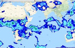
Baron Weather API now includes a global forecast of clear-air turbulence (CAT) at a specific time in the future. CAT, the turbulent movement of air masses in the absence of any visual clues such as clouds and thunderstorms, is caused by the meeting of bodies of air moving at widely different speeds. It usually occurs outside of clouds at altitudes above 15,000 feet above mean sea level (MSL), and is caused by strong wind shears in the jet stream. Pilots do their best to avoid it by adjusting their altitude or changing course. Doing that requires knowing turbulence is coming, and clear-air turbulence is almost impossible to spot. The new data product solves that problem by depicting clear-air turbulence at altitudes from flight levels 240 to 450.
Global forecasting is also available for in-cloud turbulence, otherwise known as the violent, unsteady movement of air. This product depicts in-cloud turbulence at various altitudes, from flight level 100-300, at a specific time in the future.
Also new to the Baron Weather API data offerings is a global forecast of future icing conditions. The new product depicts icing at altitudes ranging from flight level 60 to flight level 300.


